Trail Walking Gemeinde Aurach bei Kitzbühel - gebramesse - Photo
© OpenStreetMap contributors
Length
Length
5.4 km
Max alt
Max alt
1774 m
Uphill gradient
Uphill gradient
302 m
Km-Effort
Km-Effort  
9.6 km
Min alt
Min alt
1567 m
Downhill gradient
Downhill gradient
353 m
Boucle
Boucle
No
Creation date :
2019-08-18 08:19:45.034
Updated on :
2019-08-18 13:55:44.526

(0 Reviews)

Walking
Walking
2h43
Difficulty : Very easy

Scan this QR Code to open this trail in the SityTrail application

FREE GPS app for hiking

Logo SityTrail SityTrail

IGN / Geographical institutes

Download SityTrail from the App Store Download SityTrail from Google Play

Logo SityTrail SityTrail World

The world is yours!

Download SityTrail from the App Store Download SityTrail from Google Play Download SityTrail on Huawei AppGallery

About

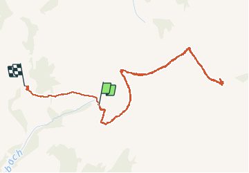
Trail Walking of 5.4 km to be discovered at Tyrol, Bezirk Kitzbühel, Gemeinde Aurach bei Kitzbühel. This trail is proposed by SaintEloi4.

Elevation profile

Positioning

Country:
Austria
Region :
Tyrol
Department/Province :
Bezirk Kitzbühel
Municipality :
Gemeinde Aurach bei Kitzbühel
Location:
Unknown
Start:(UTM)
310009 ; 5254606 (33T) N.

Trails nearby

Trail On foot Marktgemeinde Fieberbrunn - [12] Fieberbrunn Jägersteig - Photo
On foot
PRO

On foot

Easy
Marktgemeinde Fieberbrunn, Tyrol, Bezirk Kitzbühel, Austria
4.5 km | 8.6 km-effort
1h 57min
No
Trail On foot Marktgemeinde Fieberbrunn - [18] Fieberbrunn - Blumenweg - Photo
On foot
PRO

On foot

Easy
Marktgemeinde Fieberbrunn, Tyrol, Bezirk Kitzbühel, Austria
4.5 km | 7 km-effort
1h 36min
No
Trail On foot Marktgemeinde Fieberbrunn - [4] Gebraweg - Photo
On foot
PRO

On foot

Easy
Marktgemeinde Fieberbrunn, Tyrol, Bezirk Kitzbühel, Austria
3.9 km | 9.7 km-effort
2h 11min
No
Trail Walking Gemeinde Aurach bei Kitzbühel - Hochwildalm depuis Niedernberg retour par wbichlzlm - Photo
Walking
SaintEloi4

Walking

Very difficult
Gemeinde Aurach bei Kitzbühel, Tyrol, Bezirk Kitzbühel, Austria
19.4 km | 34 km-effort
5h 58min
Yes
Trail Walking Gemeinde Aurach bei Kitzbühel - jochberg höhenweg - Photo
Walking
SaintEloi4

Walking

Very easy
Gemeinde Aurach bei Kitzbühel, Tyrol, Bezirk Kitzbühel, Austria
10.2 km | 14.9 km-effort
3h 43min
Yes
Trail Walking Gemeinde Aurach bei Kitzbühel - oberaurach haselwand auwirt - Photo
Walking
SaintEloi4

Walking

Very easy
Gemeinde Aurach bei Kitzbühel, Tyrol, Bezirk Kitzbühel, Austria
8.5 km | 14.8 km-effort
3h 34min
No
Trail Walking Gemeinde Aurach bei Kitzbühel - Aurach sonnberg ebnerkapelle lackenhof aller seul - Photo
Walking
SaintEloi4

Walking

Very easy
Gemeinde Aurach bei Kitzbühel, Tyrol, Bezirk Kitzbühel, Austria
6.8 km | 0 m-effort
2h 21min
No
Trail Walking Gemeinde Aurach bei Kitzbühel - geflügelhof herrenmoos einathen - Photo
Walking
SaintEloi4

Walking

Very easy
Gemeinde Aurach bei Kitzbühel, Tyrol, Bezirk Kitzbühel, Austria
8.4 km | 12.4 km-effort
2h 34min
Yes


Close
My subscriptions